
|
Bridge Project Team Members: Amy Curtis – Project Manager, Civil Engineer
|
Suspended Bridge Project, International Senior Design, Dominican Republic CE 4905 Senior
Design Summer 2004 Introduction
Problem Statement
|
|
Background |
|
|
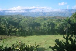
Site
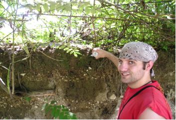
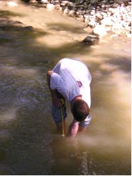
Analysis An in depth site analysis was done for two of the three sites. The third site was rejected outright due to it’s high chance for river relocation which would probably undermine any attempts to build a bridge in that location. The first site presented an excellent view of the soil layering in the area. There was a 6’ vertical cut in the bank of the river that showed alternating layers of rock and soil. Soil testing was performed on the bank using a pocket penetrometer, and Torvane shear tester. Soil was tested at varying depths and on both sides of the bank. Profiles of the site were drawn up and a rough flow calculation at the site was taken using a 2 ½ gallon plastic bag. The bag was submerged empty, and airless, then the bag was opened and timed until it was full. This was performed to give a rough estimate of flow through the river channel. This site was ultimately rejected due to being placed only a few feet upstream from a 90 degree bend in the river and very bad accessibility. It was not known how much the path of the river would change in the coming years, but since it was so close to an open corner, it was decided that the risk was too much. And to top things off, the path to the site was through a rice field which meant the trail was just a bunch of mud and fertilizer with frequent irrigation ditch crossings that made travel difficult without any loads. It would have been an unpleasant trip for the women carrying upwards of 7 gallons of water along the trail. So the second site was ultimately chosen. The stream depth at
low flow conditions was measured at 15” along the main channel where
the bridge crossing was proposed. This showed us where the center of the
river was, and where we needed the most base clearance for any trees or
debris floating down river during a flood. The first step after choosing the optimum site was to survey the proposed site and create a bridge profile based on the current stream height and river bank elevations. Surveying in the Dominican Republic was a little primitive by today's standards, but was more then effective enough to provide an accurate layout of the site. The survey crew consisted of a three person team, an Abney level and a 100’ tape measure. The person with the tape measure walks out a distance until the shooter with the Abney level was able to sight in on a feature of the other persons face. This height of the facial feature and Abney level from ground were recorded. For our survey, it was the base of the measurers nose and upper lip. The vertical angle to the measurers facial feature and distance from the shooter to measurer were recorded. A straight line along the bridge centerline was eyed and shot using this method both backwards and forwards. By combining the heights, angle of sight, and distance measured, an accurate horizontal and vertical profile was established. |
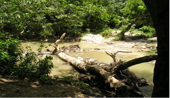
The second site visited was located along a well traveled and dry dirt
path, which solved our accessibility problems. The site was offset about
800 ft. from the main road through La Verada, which added to the convenience
of the location. The soils were tested again, and the results ended up
a little higher then site one which helped us further decide on this site.
The location of the abutments would be approximately 150 ft downstream
of a slight bend in the river path, which concerned us at first. A more
detailed look at the river path showed that both sides of the river were
heavily vegetated and though there were some signs of erosion, it was
apparent that the river had been on this present path without much meandering
for quite some time. The bridge site was located near the beginning of
a nearly ¼ mile long straight stretch of the river. The river banks
were both overgrown with trees up to 15” in diameter that grew straight
up with no major bends in the trunk suggesting that the banks hadn’t
been eroded away beneath the trees and that the trees started growing
in the same spot as they now occupy on the bank. This satisfied our bank
stability criteria by proving that the bank hadn’t moved more then
a few inches in at least 10 years. Planning and design started immediately after all the testing and surveying was completed. Lyle Stone and Father John Cervini of the local catholic church assisted in helping to compile a list of requirements that the bridge would need to meet in order to serve the public interest of the people of La Vereda. The requirements were to allow a bridge wide enough so 2 people could pass side by side, the bridge would need to be stable so as to not sway when people walked upon it and cause them to loose their balance, a way to provide a handrail system that connected to the walkway is a way to prevent anyone from falling into the river below, and if possible, be able to handle the weight of a medium sized cow or burro in case the locals needed the animals to help transport goods or people in need of medical treatment. |
Side View of Planned Bridge and Profile of River 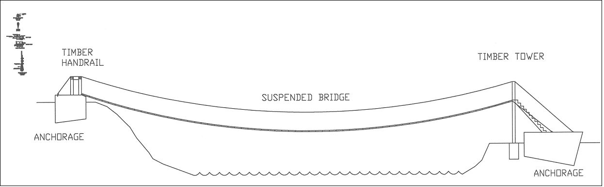
|
|
Design The design was split up into three parts.
Amy Curtis was responsible for calculations of cable sag, effects of temperature
on the steel, tension and cable design, and connections design. Mike Kalisz
was responsible for the profile drawing of the bridge in AutoCAD, slope
protection, walkway plank design, and initial specifications. Jeremy White
was responsible for the foundation analysis, anchorage design and gabiones
design. |
Along with the calculations for the bridge design itself, many other logistical problems arose. The design needed to be flexible enough to adapt to the changes of the building site one year after the initial survey. The bridge had to be designed to be able to be built in under 14 days. That includes excavation, concrete pouring, plank assembly cable tensioning and anchoring and final assembly. The main goal of the design was to be as simplistic as possible, yet still be able to meet strength and dimension requirements. Another problem that had to be solved through design was the height difference of the two river banks. With the lower bank being only 5 ft above the river height, it was impossible to have the bridge at an incline and still meet freeboard requirements for clearance underneath the bridge. A creative solution was devised using the Survey, Design, and Construction of Trail Suspension Bridges for Remote Areas book. A wooden tower will be constructed on top of the lower bank’s abutment and will bring the bridge level with the higher bank in order to create enough clearance underneath the bridge. A set of stairs will be built leading up to the tower. The only problem with this design, will be that the animals will probably not be able to be brought across the bridge now as they would have a hard time climbing up and down the stairs. One cost saving measure will be to use boulders from the river as ballast in the abutments. The rock will greatly reduce the amount of concrete needed, thereby saving a lot of money and time. Also, the slopes will be grown with native plants as part of the slope protection, and will hopefully be able to inspire some locals to think more environmentally in order to reduce the severe soil erosion problem in the country. |

Cost
Summary 
|
Summary and Conclusion
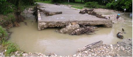
A bridge is needed
in the village of La Vereda over the Rio Valle Juelo. It is necessary
to protect the men, women and children from death due to floodwaters that
occur during the annual rainy season. This river has proved to be fatal,
just as many just like it during the floods of June 2004. The loss of
life and supplies can be prevented through the construction of a suspended
bridge. The bridge will be constructed of ¾ inch stainless steel
wire rope and connections, 2” x 6” x 4’ timber floor
planks, a timber tower, concrete and rebar anchorages, native cobble bank
protection, and trench slope protection. Material cost of the bridge reaches
a total of $3900 before donations. An additional cost of approximately
$7,000 is required to fund travel and living expenses for the designers
that will be necessary on site for anchorage placement and construction
aid. Sources for these funds will include both material and financial
donations. We would like to thank, John Cervini, Linda Philips, Lyle Stone, Matt Niskanen, Dr. Robert Baillod, Dr. Stan Vitton, Dr. William Bulleit, Dr. George Dewey, Dr. Bogue Sandberg, and Loos & Co. |
| Michigan Technological
University Department of Civil and Environmental Engineering 1400 Townsend Drive Houghton, Michigan, 49931 - 1295, USA Department Phone: 1-906-487-2520 Department Fax: 1-906-487-2943 Department E-mail: cee@mtu.edu |